ADV Studio IV Subtraction | Final

a brief intro on the site at large, the urban strategy, the realization of that strategy on the masterplan for the entire peninsula, zoom in to an area of focus that details what I refer to as a designed demolition, and continue scaling down from nature to city, nature to architecture, architecture to city and city to architecture.
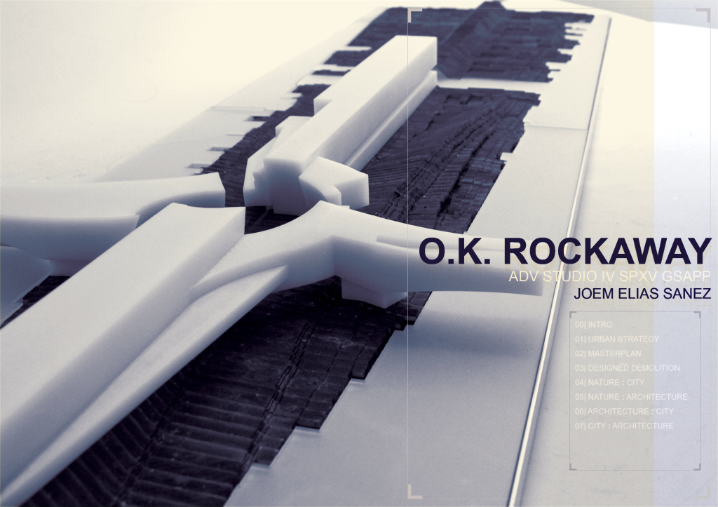


I’ll start with a brief intro on the site at large, the urban strategy, the realization of that strategy on the masterplan for the entire peninsula, zoom in to an area of focus that details what I refer to as a designed demolition, and continue scaling down from nature to city, nature to architecture, architecture to city and city to architecture.
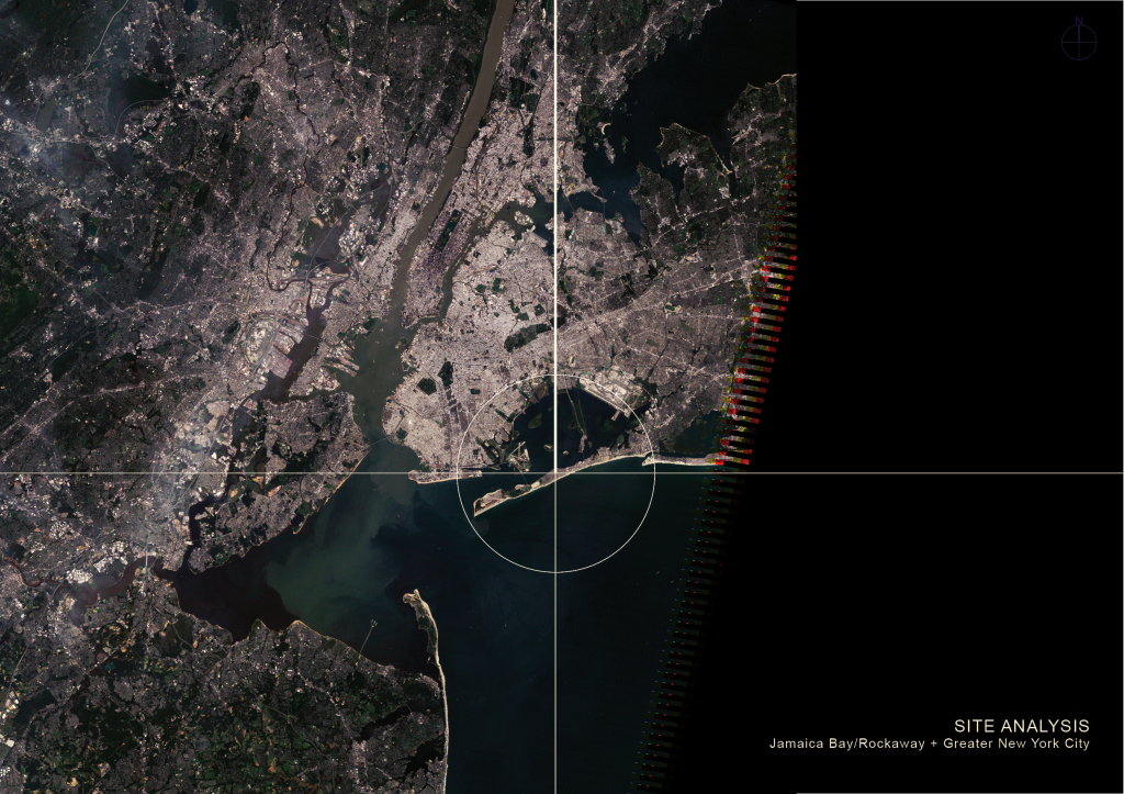
I’ll start with a brief intro on the site at large, the urban strategy, the realization of that strategy on the masterplan for the entire peninsula, zoom in to an area of focus that details what I refer to as a designed demolition, and continue scaling down from nature to city, nature to architecture, architecture to city and city to architecture.

Here we are, the Rockaway Peninsula, its immediate context, Jamaica Bay and the Greater New York City Area.
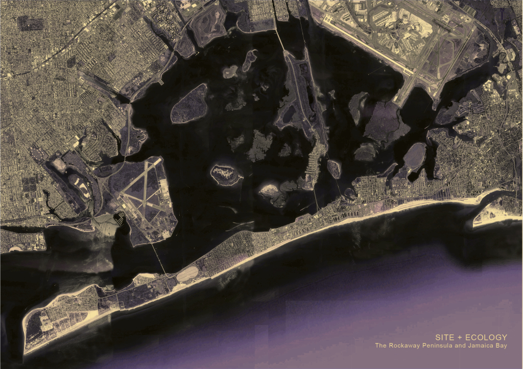
Here we are, the Rockaway Peninsula, its immediate context, Jamaica Bay and the Greater New York City Area.

Jamaica Bay has long been considered New York city’s ecological gem which can be attributed to the marshlands
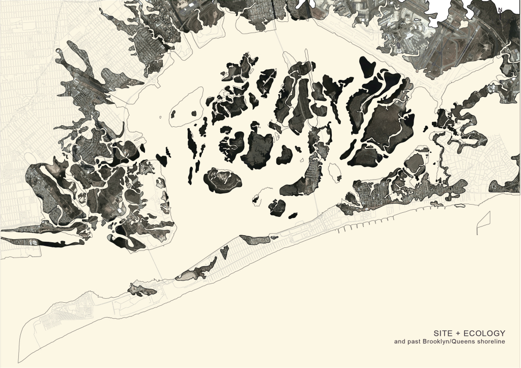
Jamaica Bay has long been considered New York city’s ecological gem which can be attributed to the marshlands

Before 1930s there was almost double the area of marsh that we have today. A good 2 miles inland from what we now know as the Jamaica Bay shoreline along Queens and Brooklyn were actually wetlands. Wetlands filter water by collecting sediments, they lessen the impact of coastal flooding…  Many of the projects in Jamaica bay are about reconstructing and restoring the wetlands.

Before 1930s there was almost double the area of marsh that we have today. A good 2 miles inland from what we now know as the Jamaica Bay shoreline along Queens and Brooklyn were actually wetlands. Wetlands filter water by collecting sediments, they lessen the impact of coastal flooding… Many of the projects in Jamaica bay are about reconstructing and restoring the wetlands.
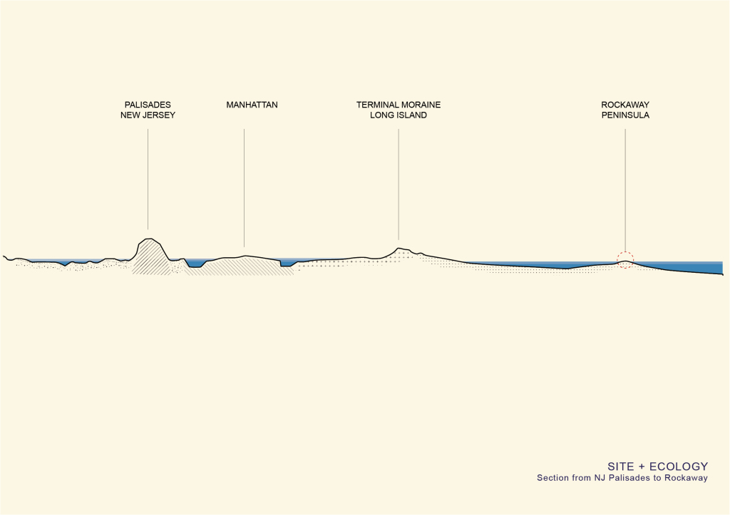
I’m interested in the relationship of the Peninsula to the Bay. You can see in this section the vast differences in elevation: fom the NJ Palisades by the Hudson river, Manhattan, to the terminal moraine in Long Island which is a glacially formed accumulation of boulders, that’s the rock formation called Outer Lands that stretches all the way to cape cod, and then we have Jamaica Bay and the Peninsula and the Sound.
I’m interested in the relationship of the Peninsula to the Bay. You can see in this section the vast differences in elevation: fom the NJ Palisades by the Hudson river, Manhattan, to the terminal moraine in Long Island which is a glacially formed accumulation of boulders, that’s the rock formation called Outer Lands that stretches all the way to cape cod, and then we have Jamaica Bay and the Peninsula and the Sound.

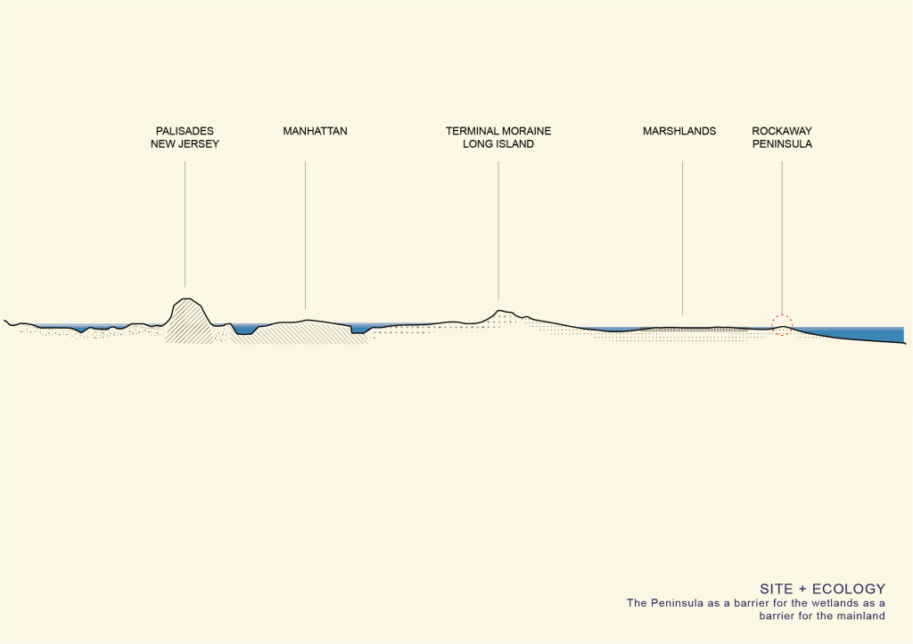
The Peninsula is already essentially acting as a barrier island for the wetlands, which act as barrier reef for the mainland. It’s like a filter before a filter.
The Peninsula is already essentially acting as a barrier island for the wetlands, which act as barrier reef for the mainland. It’s like a filter before a filter.

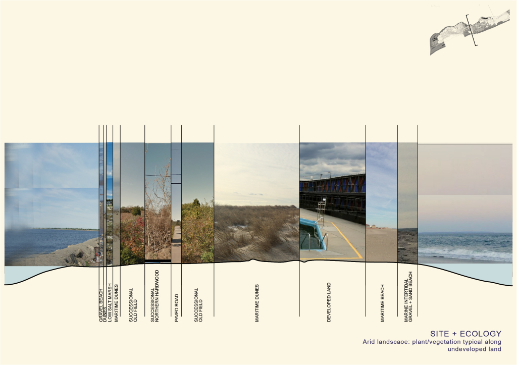
The peninsula is fairly flat with very subtle changes in elevation, mostly attributed to dunescapes, but for the most part, this is the arid landscape you’ll typically see from Breezy Point to the end of Jacob Riis Park.
The peninsula is fairly flat with very subtle changes in elevation, mostly attributed to dunescapes, but for the most part, this is the arid landscape you’ll typically see from Breezy Point to the end of Jacob Riis Park.

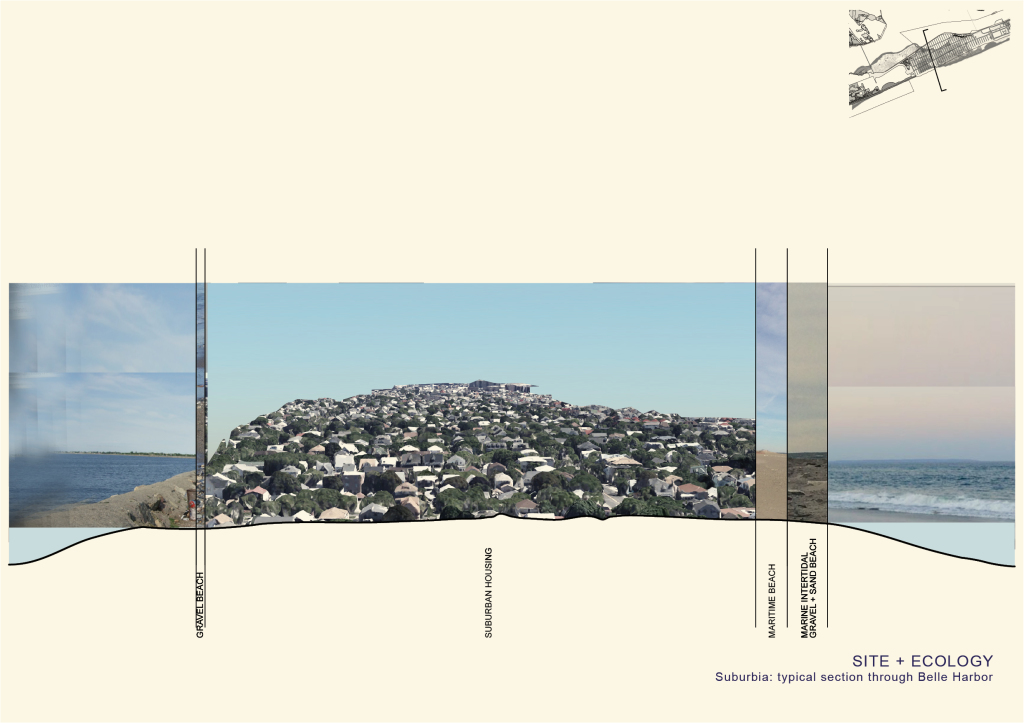
The rest of the Peninsula towards Far Rockaway are mostly developed land. This area in Belle Harbor is a very suburban area and perhaps the most affluent neighborhood in the island. But it’s still mostly entirely built on sand.
The rest of the Peninsula towards Far Rockaway are mostly developed land. This area in Belle Harbor is a very suburban area and perhaps the most affluent neighborhood in the island. But it’s still mostly entirely built on sand.

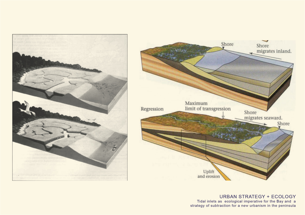
But so I started to understand the the ecosystem of breakwaters and tidal marsh inlets or tidal channels. In shallow coastal settings, channels provide a pathway for the tide to propagate and are a primary control on the sedimentation and ecology of these environments. There was an opportunity to apply a simple strategy of subtraction that would do three things: 1 engage with and sustain the wetland ecosystem 2 allow for paths for water to move through in the event of a storm surge 3 provide a building infrastructure at a higher elevation  that will relocate homes and other existing and new programs

But so I started to understand the the ecosystem of breakwaters and tidal marsh inlets or tidal channels. In shallow coastal settings, channels provide a pathway for the tide to propagate and are a primary control on the sedimentation and ecology of these environments. There was an opportunity to apply a simple strategy of subtraction that would do three things: 1 engage with and sustain the wetland ecosystem 2 allow for paths for water to move through in the event of a storm surge 3 provide a building infrastructure at a higher elevation that will relocate homes and other existing and new programs
joem_elias_sanez_gsapp_subtraction_adv_studio_IV_frampton10

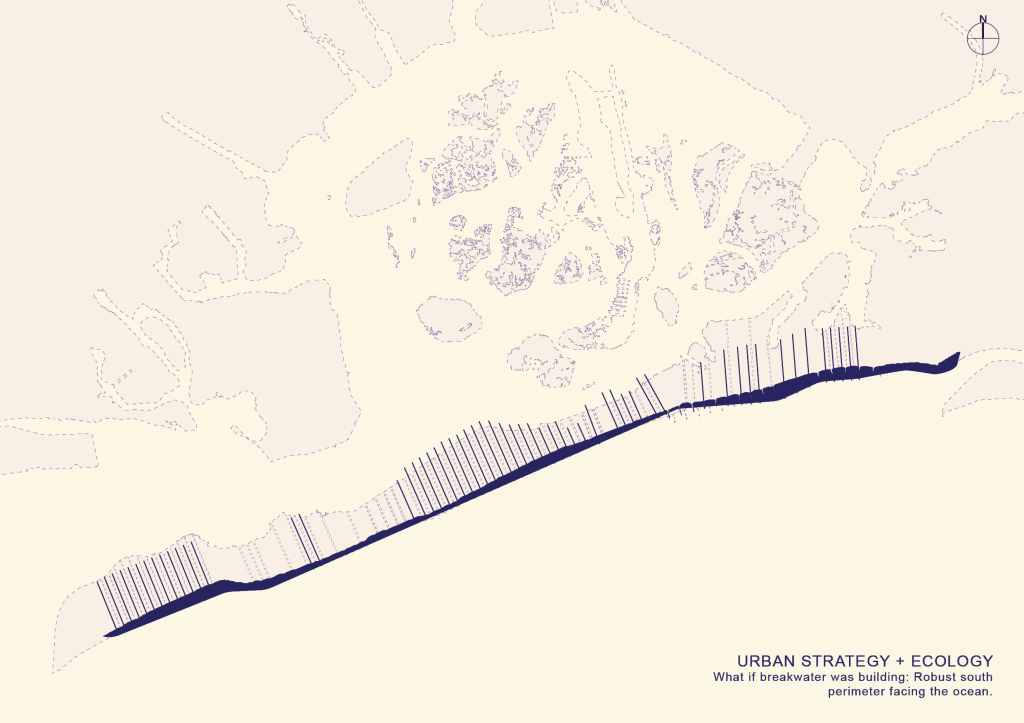
So what if building itself was breakwater -- a series of breakwater buildings that create a robust south perimeter facing the ocean. interspersed by tidal inlets that cut through the Peninsula.
So what if building itself was breakwater — a series of breakwater buildings that create a robust south perimeter facing the ocean. interspersed by tidal inlets that cut through the Peninsula.

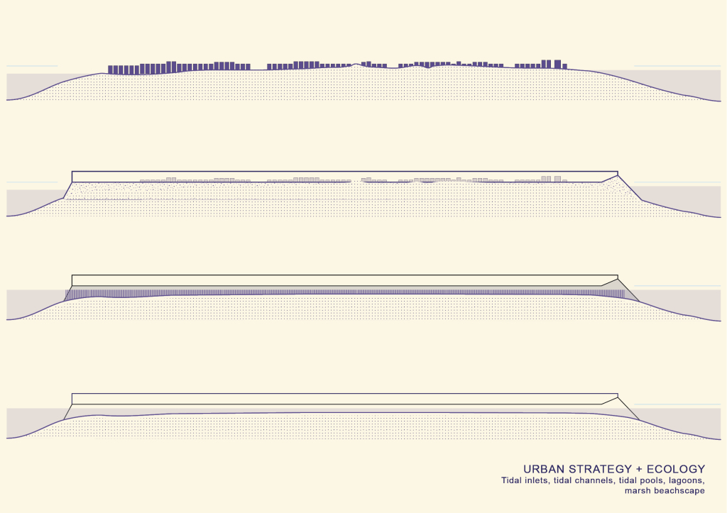
At the top, a section through Belle Harbor, at its lowest point on the north side on the left, was under 17 feet of water after Sandy. What if a everyone relocated to a building that essentially stands on a giant berm 20 feet higher than the current land elevation of the Peninsula.  And marsh inlets would cut through Or a tidal channel so water has somewhere to move through, to both accomodate and control where water should flow, instead of flooding basements etc.
At the top, a section through Belle Harbor, at its lowest point on the north side on the left, was under 17 feet of water after Sandy.
What if a everyone relocated to a building that essentially stands on a giant berm 20 feet higher than the current land elevation of the Peninsula.
And marsh inlets would cut through
Or a tidal channel so water has somewhere to move through, to both accomodate and control where water should flow, instead of flooding basements etc.

Here we are at Belle Harbor again

Here we are at Belle Harbor again

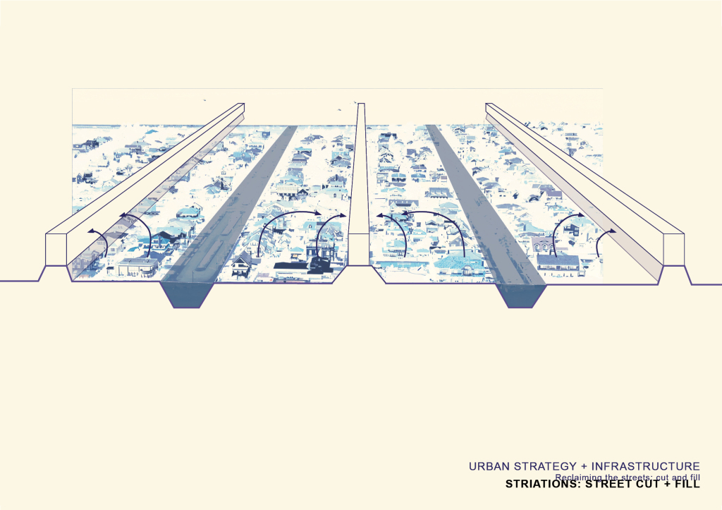
It would essentially be a cut and fill. The scheme takes every other street into an inlet and every other one into a bar on a berm. Herein, the people are relocated to the closest bar to their property.
It would essentially be a cut and fill. The scheme takes every other street into an inlet and every other one into a bar on a berm. Herein, the people are relocated to the closest bar to their property.

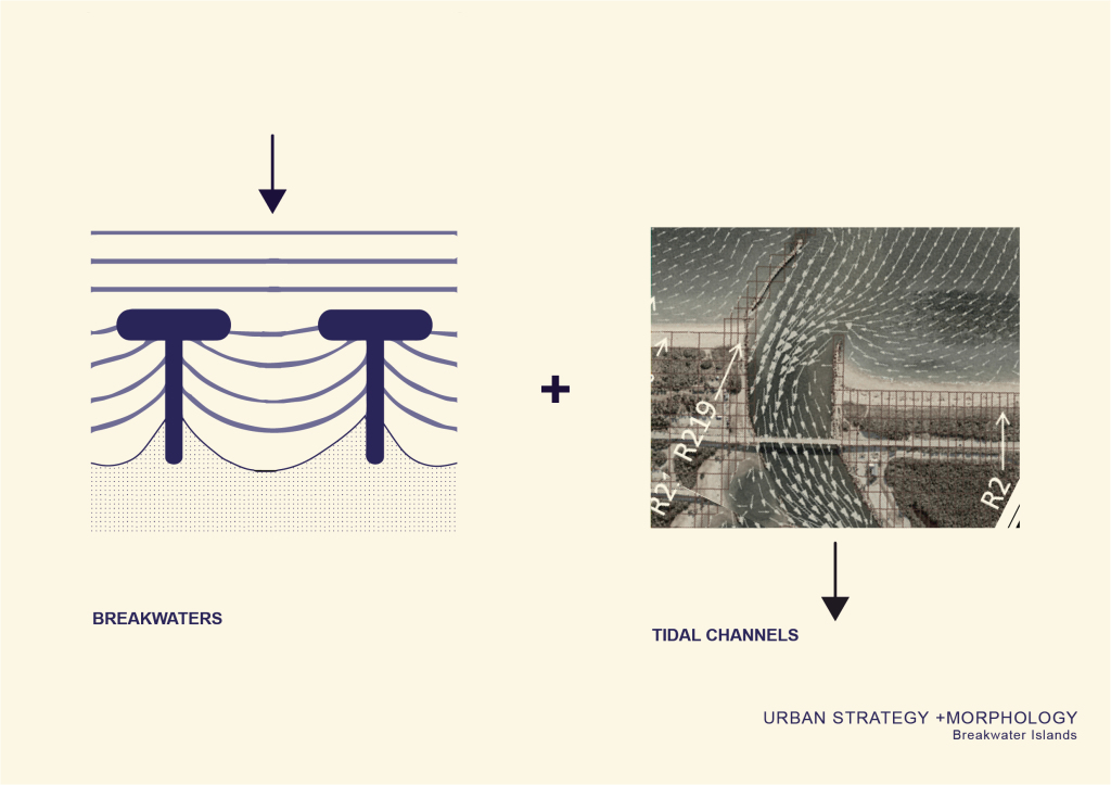
The interdependent relationship of giant breakwaters and a tidal inlets creates a certain morphology.  With regard to sedimentation, shoaling of waves, and natural eb and flow of the tides.

The interdependent relationship of giant breakwaters and a tidal inlets creates a certain morphology. With regard to sedimentation, shoaling of waves, and natural eb and flow of the tides.
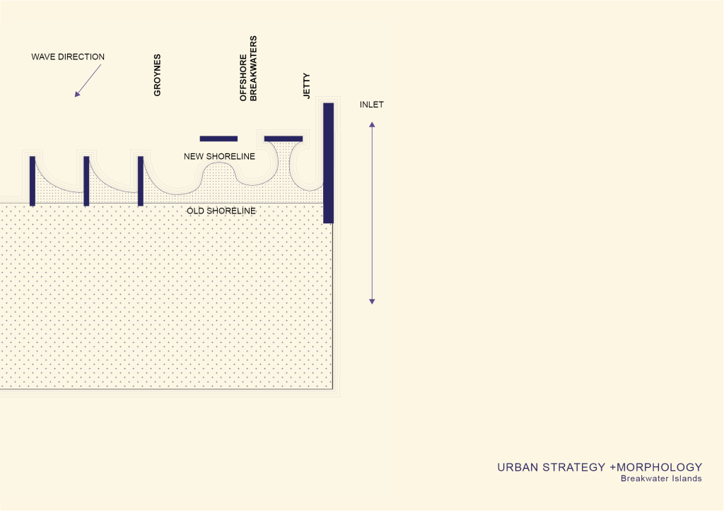
This is how we break water today: Groynes which are the stretches of rock protruding out from the island, offshore breakwaters and jetties…. This is showing the mutation of the shoreline, of land, with a single move which is essentially offsetting or protruding a bar outwards.
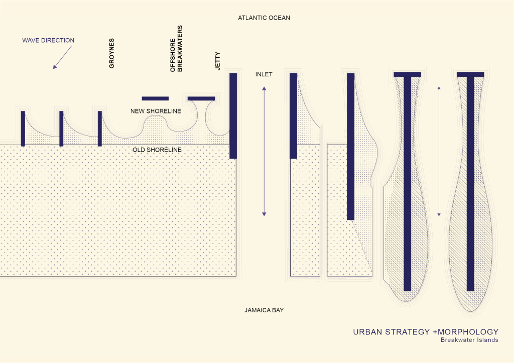
This is how we break water today: Groynes which are the stretches of rock protruding out from the island, offshore breakwaters and jetties…. This is showing the mutation of the shoreline, of land, with a single move which is essentially offsetting or protruding a bar outwards.

By the same logic, and scaling up what I’m effectively referring to as a breakwater building in the Z an the Y to traverse from atlantic shore to jamaica shore, and cutting inlets between these bars, you can imagine how a sort of designed demolition - a linear subtraction, an excavation between breakwater bars -- would gradually morph the peninsula into these island dunes.

By the same logic, and scaling up what I’m effectively referring to as a breakwater building in the Z an the Y to traverse from atlantic shore to jamaica shore, and cutting inlets between these bars, you can imagine how a sort of designed demolition – a linear subtraction, an excavation between breakwater bars — would gradually morph the peninsula into these island dunes.
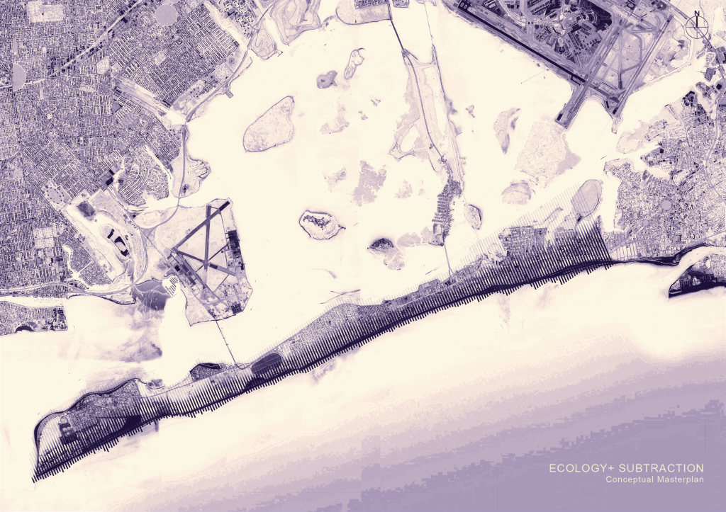
concpetually, it’s an endless repetition of bars interspersed by tial inlets that together mitigate the effects of storm surges and maintain the ecology of the marshlands in the bay in the north.
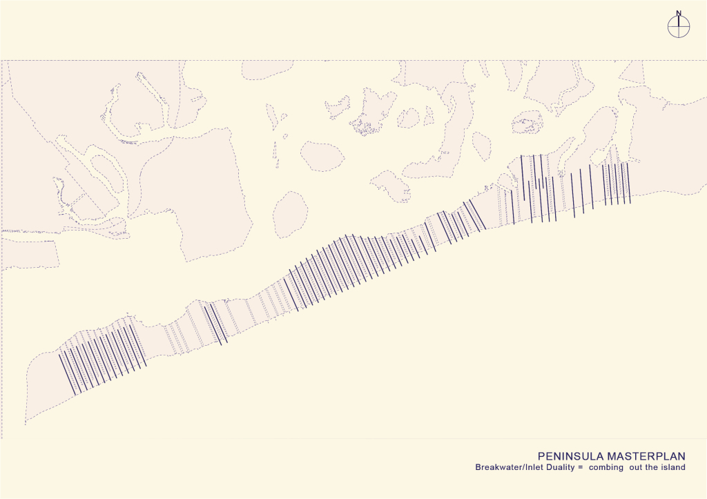
concpetually, it’s an endless repetition of bars interspersed by tial inlets that together mitigate the effects of storm surges and maintain the ecology of the marshlands in the bay in the north.

So the masterplan is a resolution of this fairly aggressive urban strategy on the entire island.

So the masterplan is a resolution of this fairly aggressive urban strategy on the entire island.

Here is the peninsula

Here is the peninsula

Tidal Channels

Tidal Channels

Breakwater Buildings

Breakwater Buildings

Together. combing out the island The very  linear scheme perpendicular to the peninsula creates a fluid connection between the ocean, the peninsula and the bay
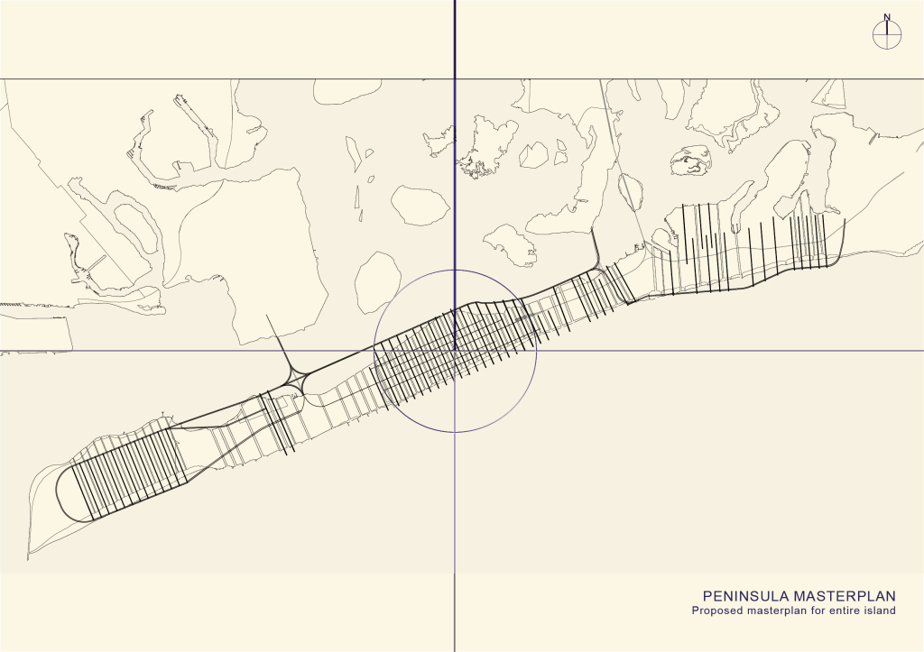
Together. combing out the island
The very linear scheme perpendicular to the peninsula creates a fluid connection between the ocean, the peninsula and the bay

but at the same time acting as a breakwater Barrier for the bay

but at the same time acting as a breakwater Barrier for the bay

Here are the High Density Areas

Here are the High Density Areas

This is the lateral network

This is the lateral network

which is denser in these areas… by the logic of the street infrastructure relocation

which is denser in these areas… by the logic of the street infrastructure relocation

The Masterplan.. overlaid over existing.

The Masterplan.. overlaid over existing.

Belle Harbor has a uniform, evenly spaced street grid parallel to the peninsula so the ecological and infrastructural desires of the masterplan are best metabolized and tested in this swatch of the island
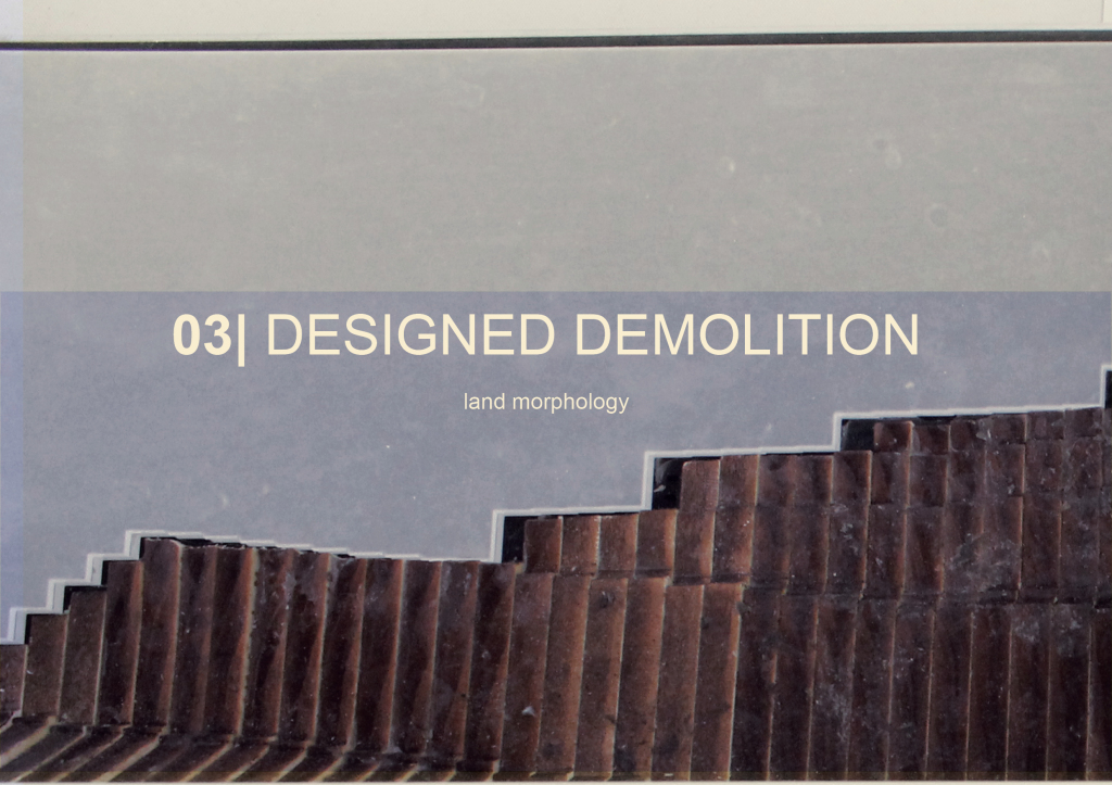
Belle Harbor has a uniform, evenly spaced street grid parallel to the peninsula so the ecological and infrastructural desires of the masterplan are best metabolized and tested in this swatch of the island

which. through this designed demolition, will show phases of land morphology from initial cut and fill to proposed land formation due to the bar/and hammerhead breakwater geometry
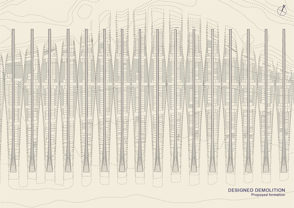
which. through this designed demolition, will show phases of land morphology from initial cut and fill to proposed land formation due to the bar/and hammerhead breakwater geometry

here’s the initial phase, where you get this series of cul de sac islands

here’s the initial phase, where you get this series of cul de sac islands

channels widen, nature reclaims what was existing in this we zone, naturally erodes

channels widen, nature reclaims what was existing in this we zone, naturally erodes

island formation due to the breakwater geometry

island formation due to the breakwater geometry

footprints of old buildings become tidal pools

footprints of old buildings become tidal pools

and the proposed formation with the this combing of the island, via bars that widen as ithe slope on the southern most tip facing the ocean
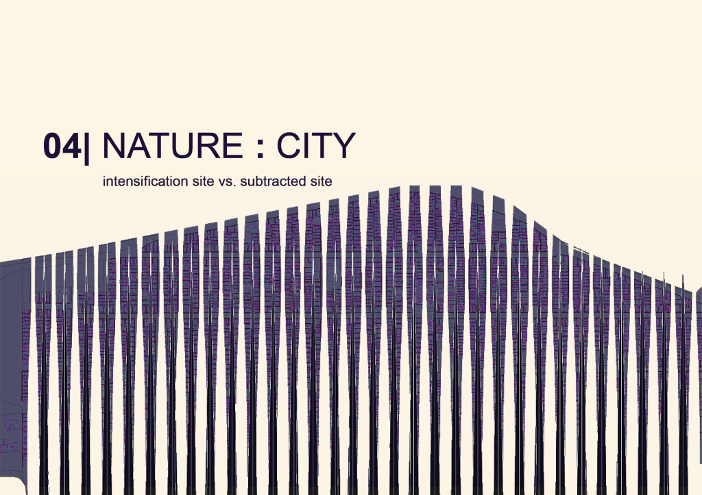
and the proposed formation with the this combing of the island, via bars that widen as ithe slope on the southern most tip facing the ocean

So theres this polarity between subtracted site and intensification site that is almost equal. And nature, the landscape between is where they begin operating as one
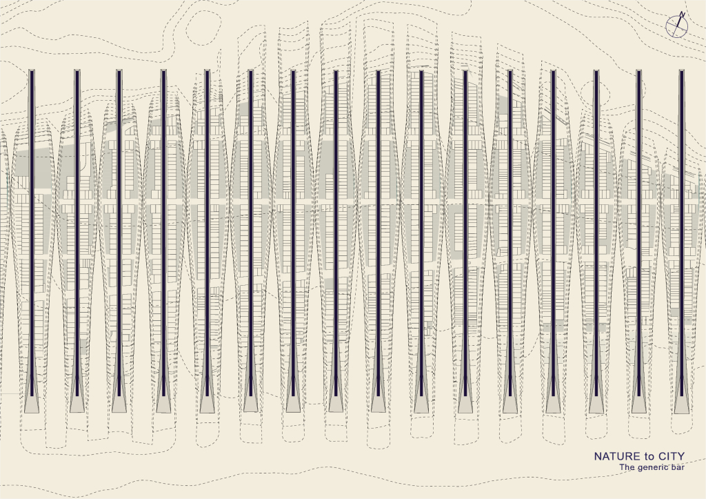
So theres this polarity between subtracted site and intensification site that is almost equal. And nature, the landscape between is where they begin operating as one

this endless repetition of 30-60 ft wide generic bars lay on these berms area anchored on these berms
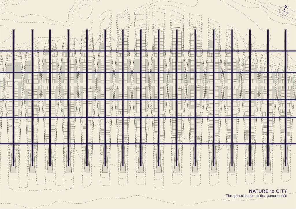
this endless repetition of 30-60 ft wide generic bars lay on these berms area anchored on these berms

And a lateral network would intersect them typically like so, so now we have a generic mat.. a carpet. low rise, high density, homogenous in its layout, with a systematic repetition of a simple element
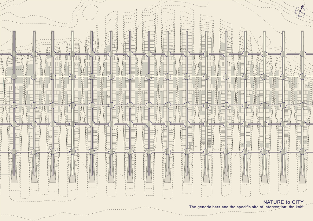
And a lateral network would intersect them typically like so, so now we have a generic mat.. a carpet. low rise, high density, homogenous in its layout, with a systematic repetition of a simple element

Mats typically weave and become formally dense at collisions, intersections are core nodes.

Mats typically weave and become formally dense at collisions, intersections are core nodes.

But if these collisions are interrupted, or never quite happen

But if these collisions are interrupted, or never quite happen

the Subtracted nodes become the specific sites of design intervention in a fundamentally horizontal field of generic bars.
the Subtracted nodes become the specific sites of design intervention in a fundamentally horizontal field of generic bars.

the erasure of the intersection is the only time one is released from the infrastructure of the bars. They become these grand landscapes within the perimeter of the built but bleed onto the terrain of the unbuilt.
the erasure of the intersection is the only time one is released from the infrastructure of the bars. They become these grand landscapes within the perimeter of the built but bleed onto the terrain of the unbuilt.

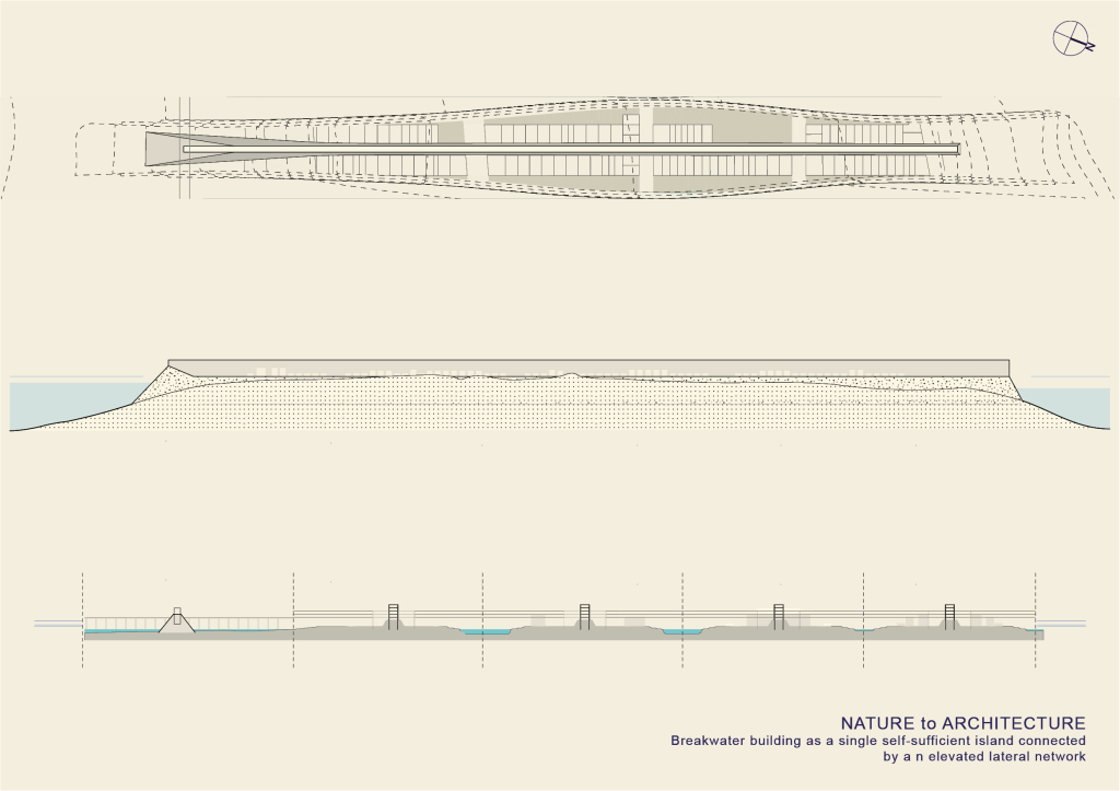
As a single island a bar then becomes a self-sufficient block connected to its neighboring blocks only by an elevated lateral network, bracing them in place, hovering over wetlands.
As a single island a bar then becomes a self-sufficient block connected to its neighboring blocks only by an elevated lateral network, bracing them in place, hovering over wetlands.

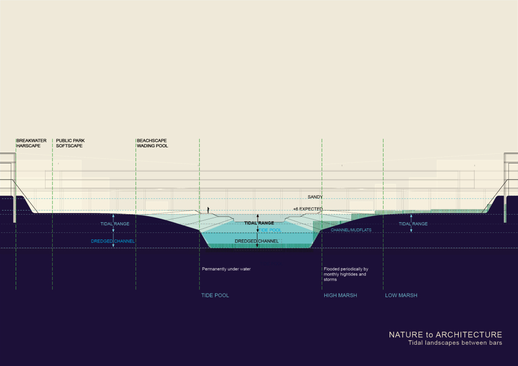
The wet inlets have a sort of stepped landscape between the lowest tide and the highest tide. These are landscape opportunities within the grid of beached canals, where the ground is wet for periods of the day -- and dry, accessible at other times. It’s essentially becomes  a wetland but a landscaped, beached lagoon. The idea is to create tidal inlets and pools that embrace the realities of living with both the buoyancy and volatility of water.
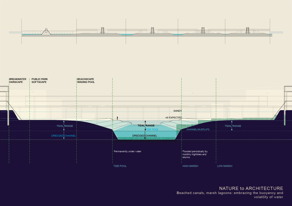
The wet inlets have a sort of stepped landscape between the lowest tide and the highest tide. These are landscape opportunities within the grid of beached canals, where the ground is wet for periods of the day — and dry, accessible at other times. It’s essentially becomes a wetland but a landscaped, beached lagoon. The idea is to create tidal inlets and pools that embrace the realities of living with both the buoyancy and volatility of water.

These tidal inlets vary in section - from a 50 foot wide canal, to an 80 feet shallow stream, to a 100-200 foot wide deeper channel.

These tidal inlets vary in section – from a 50 foot wide canal, to an 80 feet shallow stream, to a 100-200 foot wide deeper channel.
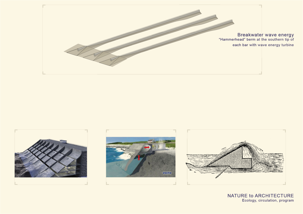
So the each breakwater bar widens as it slopes at the south end towards the ocean, creating a hammerhead, which is imperative for the  island  formation but is also the formal stimulus for harnessing wave energy in a capture chamber, which compresses water and air within this tidal pool and converts energy through a large turbine.
So the each breakwater bar widens as it slopes at the south end towards the ocean, creating a hammerhead, which is imperative for the island formation but is also the formal stimulus for harnessing wave energy in a capture chamber, which compresses water and air within this tidal pool and converts energy through a large turbine.

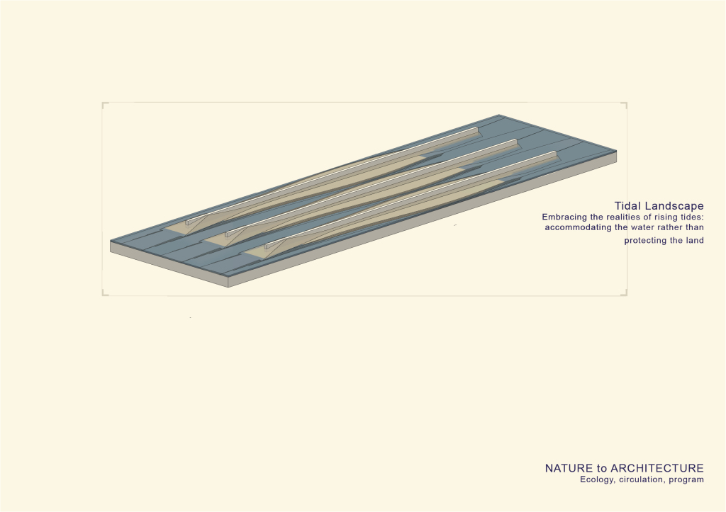
Just going through the systems: the tidal landscape that accomodate the water rather than protecting the land
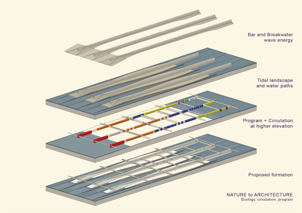
Just going through the systems: the tidal landscape that accomodate the water rather than protecting the land

Each bar as a generic container that accomodates all types

Each bar as a generic container that accomodates all types

And the Proposed, generic formation

And the Proposed, generic formation

….which will lead us to the specific, as the architectural formation of a set of bars becomes this city.
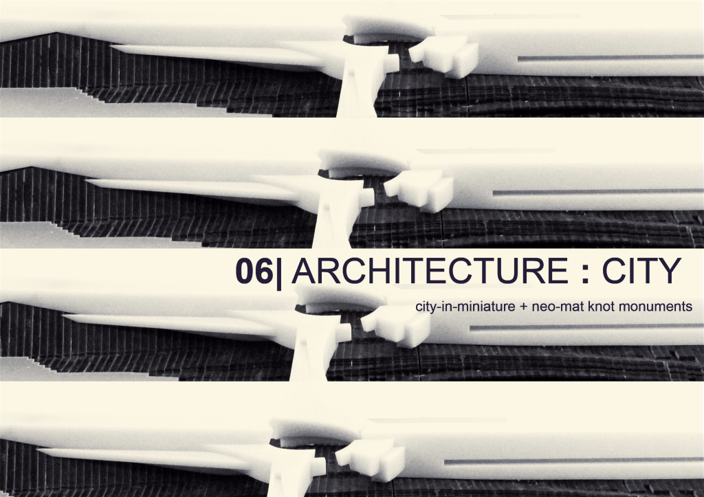
….which will lead us to the specific, as the architectural formation of a set of bars becomes this city.

This new infrastructure became this city-in-miniature. with the idea of encompassing urbanism within one complex.

This new infrastructure became this city-in-miniature. with the idea of encompassing urbanism within one complex.

a bar is organized as a self contained world but as a system it’s a whole city.

a bar is organized as a self contained world but as a system it’s a whole city.

with neo-mat-like monuments at these subtracted knots. They monumentalize the space while still remaining a low lying ground condition
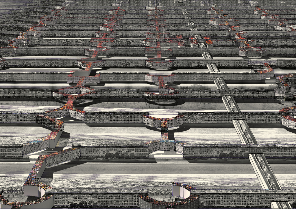
with neo-mat-like monuments at these subtracted knots. They monumentalize the space while still remaining a low lying ground condition

As a city it is centerless at the macro but each bar is punctuated at key moments at the micro. The masterplan asks what to do at the knots. These centers that happen to be the ellipsis between bars that have been interrupted
As a city it is centerless at the macro but each bar is punctuated at key moments at the micro. The masterplan asks what to do at the knots. These centers that happen to be the ellipsis between bars that have been interrupted

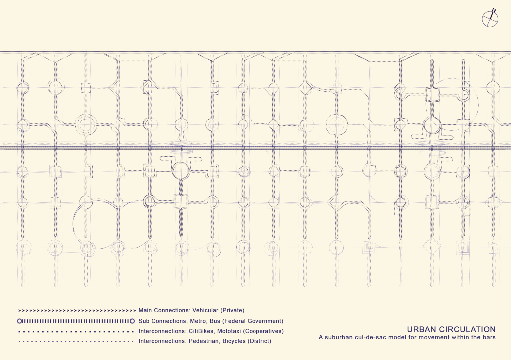
Urban circulation Vehicular, Metro and pedestrian circulation. The buildings are streets at level 2-3 where you arrive from the highway on the north side, and encounter roundabouts as you make your way south. Metro runs here with two stops 9 bars apart.
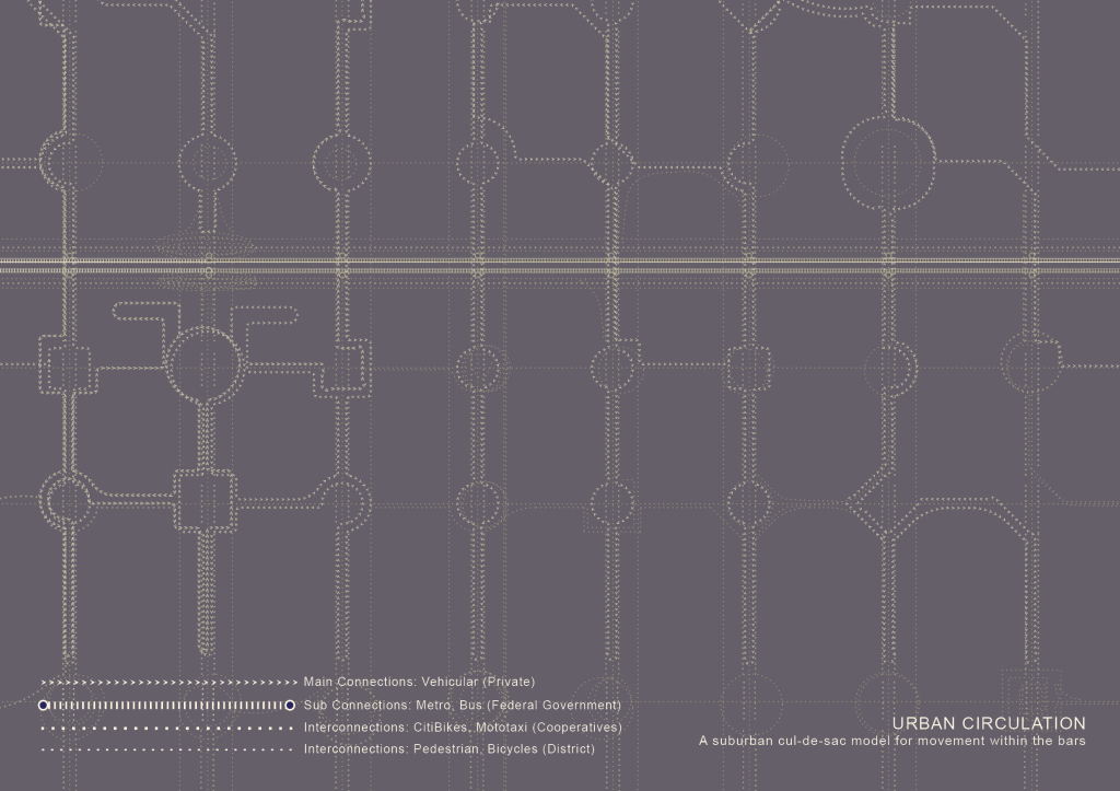
Urban circulation Vehicular, Metro and pedestrian circulation. The buildings are streets at level 2-3 where you arrive from the highway on the north side, and encounter roundabouts as you make your way south. Metro runs here with two stops 9 bars apart.

Buses run along the same lateral thoroughfare and stop at every bar. And citiBikes and Motortaxis  run the  length of the bar on the exterior terrain. And pedestrians can walk everywhere except water.

Buses run along the same lateral thoroughfare and stop at every bar. And citiBikes and Motortaxis run the length of the bar on the exterior terrain. And pedestrians can walk everywhere except water.
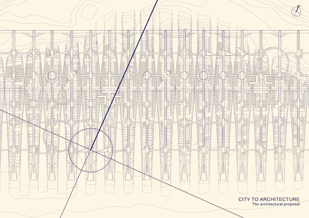
There are 96 intersections at Belle Harbor alone along 16 bars. Whatever happens at those intersections is whatever happens at those intersection depending on program and
There are 96 intersections at Belle Harbor alone along 16 bars. Whatever happens at those intersections is whatever happens at those intersection depending on program and

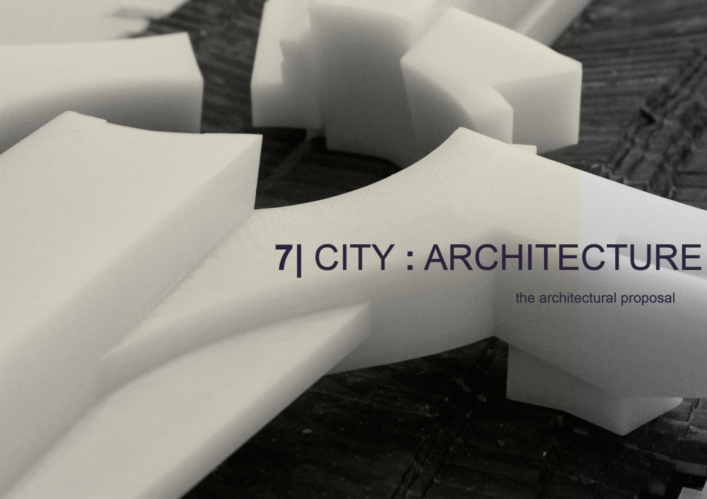
I focused on a single one. a single type of knot, which happened to be a school. a uni. a Waterways Experiment Station for the Graduate Institute of the Coastal Hydraulics Laboratory of the US Army Corps of Engineers in collaboration with the American Geological Institute.
I focused on a single one. a single type of knot, which happened to be a school. a uni. a Waterways Experiment Station for the Graduate Institute of the Coastal Hydraulics Laboratory of the US Army Corps of Engineers in collaboration with the American Geological Institute.

I’ll quickly walk

I’ll quickly walk

through the plans with you.

through the plans with you.

and zoom in on a few key areas in this self contained world that kind of resembled a ship

and zoom in on a few key areas in this self contained world that kind of resembled a ship

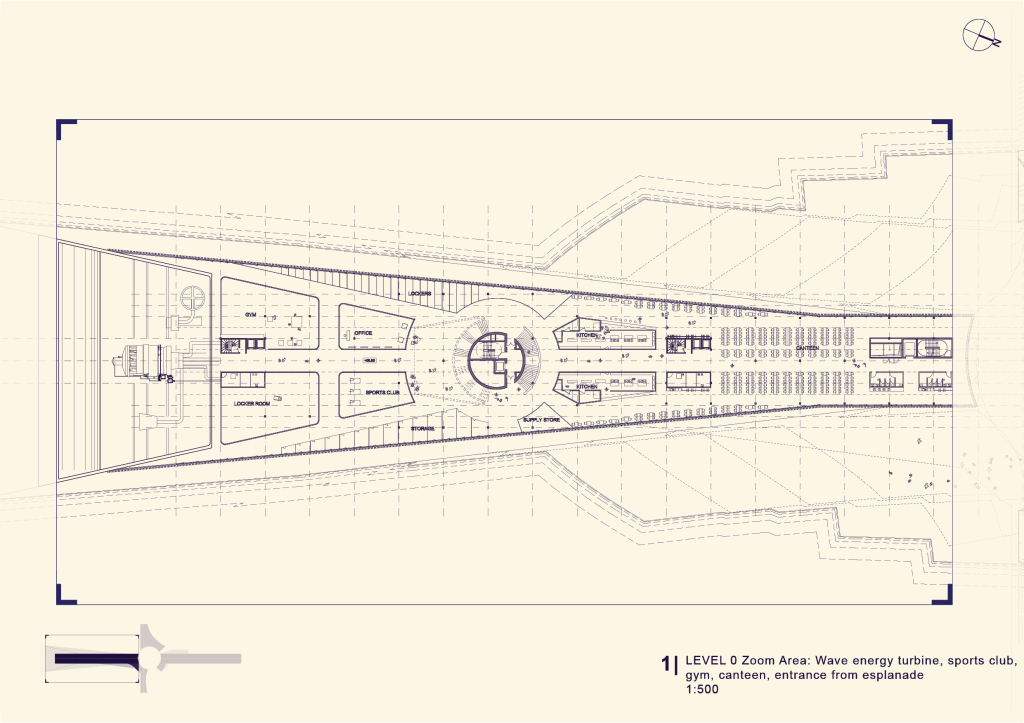
a harbored ship. with We’re at level 0 which is at +20. we’re on top of the berm. The wave energy turbine at the south. public and accessible program on this floor such as the sports club, a gym, a massive canteen and the entrance from the esplanade
a harbored ship. with We’re at level 0 which is at +20. we’re on top of the berm. The wave energy turbine at the south. public and accessible program on this floor such as the sports club, a gym, a massive canteen and the entrance from the esplanade

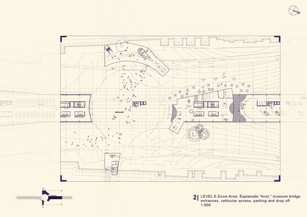
the esplanade or the nave, the knot, the subtracted hub,  is where you enter the brige crossing east west which doubles as a maritime museum. Parking and drop off at level 0 and level 1.
the esplanade or the nave, the knot, the subtracted hub, is where you enter the brige crossing east west which doubles as a maritime museum. Parking and drop off at level 0 and level 1.

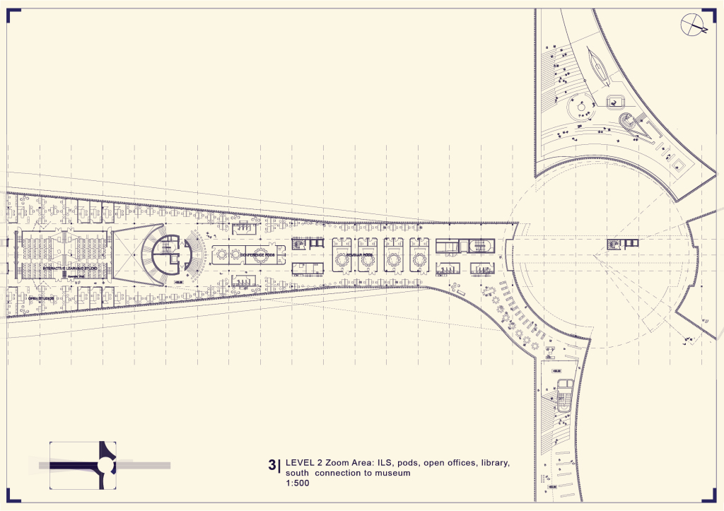
At level 2, Interactive Learning Studios, conference pods, open offices and a library that connects to level 1 of the museum

At level 2, Interactive Learning Studios, conference pods, open offices and a library that connects to level 1 of the museum

Level 3, Technology enabled labs, dry labs and wet labs, library to museum connection and the circulation along the main museum space (this ends where this begins), as well as the stacks along the bridge connecting the north to the south of campus, public auditorium up north.  programing the knot

Level 3, Technology enabled labs, dry labs and wet labs, library to museum connection and the circulation along the main museum space (this ends where this begins), as well as the stacks along the bridge connecting the north to the south of campus, public auditorium up north. programing the knot

level 4: the generic bar that accomodates all types. These are dormitories.

level 4: the generic bar that accomodates all types. These are dormitories.

finally

finally

the long section through the bar

the long section through the bar

and the

and the

sphere subtracted

sphere subtracted

that turned this knot into a both a monument for an institution and a grand public space.

that turned this knot into a both a monument for an institution and a grand public space.

joem_elias_sanez_gsapp_subtraction_adv_studio_IV_frampton72 joem_elias_sanez_gsapp_subtraction_adv_studio_IV_frampton73 joem_elias_sanez_gsapp_subtraction_adv_studio_IV_frampton74 joem_elias_sanez_gsapp_subtraction_adv_studio_IV_frampton75 joem_elias_sanez_gsapp_subtraction_adv_studio_IV_frampton76 joem_elias_sanez_gsapp_subtraction_adv_studio_IV_frampton77 joem_elias_sanez_gsapp_subtraction_adv_studio_IV_frampton78 joem_elias_sanez_gsapp_subtraction_adv_studio_IV_frampton79